By the year 1800 in England, the country had been divided and sub-divided into administrative areas. The smallest area was known as a parish and administered by officials who originally held their meetings in the vestry at the local church (known as the parish church), hence the name vestry meetings. The church had a far greater role in local government before the establishment of parish councils throughout England in 1894. The parish of Pamber is a parish of ancient origin (established at least since 1166) but from Victorian times, and possibly much earlier, the parish church, known as Pamber Priory, was located just over the parish border in the neighbouring parish of Monk Sherborne, presumably because when it came to organising parish boundaries it was decided that the Pamber Priory Church was too far from the rest of the Pamber area to keep it within the parish. The outcome was that Pamber Priory Church was annexed to Pamber for church purposes and acted as the parish church for its people, even though actually located within the parish of Monk Sherborne. There was another church in the parish of Monk Sherborne and that was used as the parish church for the people resident in that area.
The name Pamber comes from the word Penbere. Pen means pen or fold and bere means a woodland used for swine pasture. Pamber parish consisted of three districts, as it still does today. Pamber End is the district in the south of the parish, Pamber Green is the district in the middle of the parish and Pamber Heath is the district in the north of the parish. Much of the parish was and still is covered by an ancient woodland known as Pamber Forest.
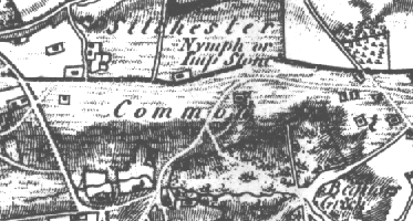 An
early Ordnance Survey map, originally dated the 11th of
August, 1817 (from a survey mainly undertaken between 1808-1817
but with later revisions included), shows no settlement in
the area now known as Pamber Heath (except for one
unidentifiable building), as you can see from the picture
here.
An
early Ordnance Survey map, originally dated the 11th of
August, 1817 (from a survey mainly undertaken between 1808-1817
but with later revisions included), shows no settlement in
the area now known as Pamber Heath (except for one
unidentifiable building), as you can see from the picture
here.
You will note that the land which the village now occupies, was part of `Silchester Common', which was a section of the large area of common land which stretched between Silchester and Heath End (to the West of Tadley). A common was historically that area of land where local people had the right to gather firewood, graze their livestock and so on, each person having shared rights to the land - hence the reason for being called common land. The oldest recorded landmark in the area was the 'Nymph or Imp Stone', a supposed Roman mile stone which still stands at the junction of Impstone Road and Silchester Road.
In 1824, an Act of Enclosure for Pamber was passed and in 1825 allotments were put up for sale in Pamber. It was to be two years later in 1827 that the commissioners, appointed under the Act, finally published the Document of Enclosure for Pamber, detailing the distribution of areas of land and establishing a public gravel pit in the parish, which was to be located at Pamber Heath. An enclosure map was also published, detailing allotments, landowners and the location of the public gravel pit - see the Events page. The first settlers were members of the Simpson family.
The Tithe map of the parish of Pamber, dated September 1839, and accompanying Tithe Award, revealed that there were only four dwellings in the area at the time: Four `tenements and gardens' were listed and mapped in the area now known as `The Glen' - Daniel Simpson was given as the occupier of two tenements and David and Timothy Simpson occupiers of the other two. The Simpsons were also shown as occupying other small parcels of land around their dwellings - for use as paddocks, meadow, arable cultivation etc. Tithes were a form of local taxation to fund the clergy.
Burney Bit was a `Plantation' and the `Red House Estate' area and everything north of it was recorded as `Heath', as was the Impstone Road area to the east. The public gravel pit was shown, which is now the land on which the Memorial Hall and tennis courts stand. Each parcel of land was named as `Common Piece' and owned by various individuals, except for the area now known as the `Red House Estate'- that was owned by Queens College, Oxford. No village name was given. No roads existed in 1839, except for part of what is now Pamber Heath Road.
Development was gradual after 1839. There were about 25 dwellings by 1851 and 65 by 1871. People rented allotments for small-scale farming purposes and to grow crops for food, as well as for keeping livestock such as cows and pigs. Locals had built dwellings on their allotments, even though the land was not owned by them and apparently without consent.
Ordnance Survey produced the first 25 inch map of the village in 1872, which gave a clear record of the location of buildings and parcels of land. A small village had been established. The only place of worship shown was the Plymouth Brethren's Chapel in Pamber Heath Road and the only public house was the `Pelican Inn', in Silchester Road. Burney Bit, Silchester Road and Impstone Road were all just footpaths then and the only roads were Church Road, part of Clapps Gate Road and part of Pamber Heath Road. No road names were given but the village was named `Pamber Common'.
The 1881 and 1891 Census records show that there was little change in the number of dwellings - about 70 dwellings in total by 1881, falling to about 61 by 1891.
The 1896 25 inch Ordnance Survey map revealed that there had been little change in the village since 1872 - the Infant's school had appeared in Church Road but little else of note. Unfortunately, no road names were shown but the village was still named as `Pamber Common'.
In 1897, particulars of sale for the auction of land in Pamber Heath revealed road names and current occupiers, showing that Burney Bit was recorded as `Burney Piece', Clapps Gate Road as `Middle lane' and Church Road as `Common Road'. Many locals were able to buy the allotments that they had previously rented which put an end to the unsatisfactory state that had existed, in the view of the landowner at the time, as many had built dwellings on their rented allotments.
The 1911 25 inch Ordnance Survey map showed much more in the way of development - many more buildings in Burney Bit and a general increase in dwellings overall. The `Red House' had appeared in Church Road and `The White House' in Impstone Road but still no road names were shown. The village was now named as `Pamber Heath'.
Most major development took place after the Second World War, starting with the building of council houses in Burney Bit.
In summary, from the early maps and census returns, it is clear that Pamber Heath only has a history of about 200 years with no evidence of ancient history, such as medieval or Roman settlements.